Electrical Resistivity Survey

      Rs

      Description


      Electrical Resistivity Survey: Uncover Subsurface Secrets

      Gain valuable insights into the subsurface with our comprehensive Electrical Resistivity Survey. This non-invasive geophysical method provides detailed information about the geological structure and properties of the earth beneath the surface. Ideal for a wide range of applications, our survey helps you make informed decisions in various industries, from environmental assessment to construction and mining.

      What is Electrical Resistivity?

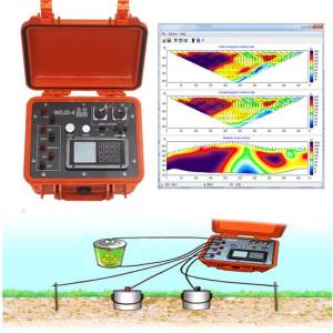
      Electrical resistivity is the measure of a material's ability to oppose the flow of electric current. Different subsurface materials (e.g., soil, rock, water) exhibit distinct resistivity values. By injecting electric current into the ground and measuring the potential difference, we can create a resistivity model that maps variations in subsurface resistivity. These variations reveal important information about:

      • Soil and Rock Layers: Identify different geological formations, their thickness, and their lateral extent. This is crucial for understanding stratigraphy, identifying aquifers, and characterizing bedrock.
      • Groundwater Contamination: Locate plumes of contaminated groundwater by identifying areas of lower resistivity associated with saltwater intrusion or the presence of conductive contaminants.
      • Geological Structures: Detect faults, fractures, and other geological structures that can influence groundwater flow and stability.
      • Utility Mapping: Locate buried utilities, pipelines, and cables to prevent accidental damage during construction or excavation.
      • Foundation Engineering: Assess the suitability of soil for construction projects by identifying weak zones, potential voids, or unstable layers.
      • Mineral Exploration: Identify potential mineral deposits by mapping variations in resistivity associated with different mineralizations.

      Our Survey Methodology:

      We employ state-of-the-art equipment and experienced geophysicists to ensure accurate and reliable results. Our typical survey process involves:

      1. Site Reconnaissance: A preliminary site visit to assess the area, identify potential access points, and discuss project specifics.
      2. Data Acquisition: We utilize various techniques, including:
        • Vertical Electrical Sounding (VES): Provides information on the vertical variation of resistivity.
        • Electrical Resistivity Tomography (ERT): Creates a two- or three-dimensional image of subsurface resistivity variations. This method provides a high-resolution image of the subsurface.
      3. Data Processing and Interpretation: Our expert geophysicists process the raw data using advanced software to create detailed resistivity models and interpret the results.
      4. Report Delivery: A comprehensive report is delivered, including maps, cross-sections, and an interpretation of the subsurface conditions. The report clearly outlines the findings and their implications for your specific project.

      Benefits of Choosing Our Electrical Resistivity Survey:

      • Non-invasive: No excavation or drilling is required, minimizing environmental impact and cost.
      • Cost-effective: Provides detailed subsurface information at a fraction of the cost of traditional methods like drilling.
      • High Resolution: ERT techniques offer high-resolution images of subsurface structures.
      • Rapid Data Acquisition: Data acquisition is relatively quick, minimizing project downtime.
      • Experienced Professionals: Our team consists of highly experienced and qualified geophysicists.

      Contact us today to discuss your project requirements and learn how an Electrical Resistivity Survey can provide valuable insights into your subsurface. We offer customized surveys to meet your specific needs and budget. Get a free quote!

      Looking for Best Price

      Tags: Electrical Resistivity Survey