Description
Here's a detailed product description for "3DMappingLayout" in Markdown format, designed to be comprehensive and engaging:
🌐 3DMappingLayout: Precision Spatial Planning & Intelligent Environment Design
Unlock the Full Potential of Your Physical World with Dynamic 3D Mapping and Layout Capabilities.
In today's complex environments, traditional 2D blueprints and static models fall short. Introducing 3DMappingLayout, the revolutionary platform that empowers professionals to visualize, plan, design, and optimize any physical space with unparalleled accuracy, realism, and intelligence. From urban landscapes to intricate indoor facilities, transform your data into actionable 3D layouts and drive smarter decisions.
✨ What is 3DMappingLayout?
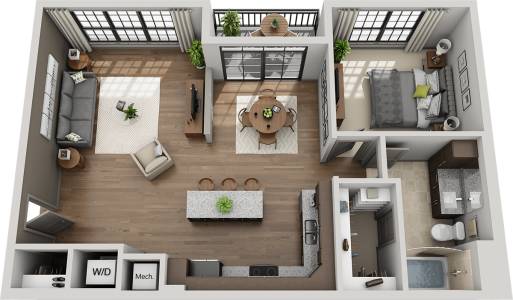
3DMappingLayout is an advanced, enterprise-grade software solution that seamlessly integrates diverse spatial data (LiDAR, photogrammetry, GIS, CAD, BIM) to create highly accurate and interactive 3D digital twins of real-world environments. Beyond mere visualization, it provides powerful tools to design, arrange, analyze, and simulate layouts within these precise 3D contexts, revolutionizing planning across various industries.
🚀 Key Features & Capabilities:
1. Advanced 3D Mapping & Data Integration
- Multi-Source Data Ingestion: Effortlessly import and merge data from LiDAR scans, drone photogrammetry, satellite imagery, CAD files (DWG, DXF), BIM models (IFC, RVT), and GIS databases (ESRI Shapefile, GeoJSON).
- High-Fidelity Point Cloud & Mesh Handling: Process and render massive point clouds and textured 3D meshes with exceptional detail and performance.
- Geo-Referencing & Alignment: Automatically or manually align disparate datasets to create a single, cohesive, georeferenced 3D environment.
- Real-time Data Updates: Connect to live IoT sensor feeds or real-time data streams to visualize dynamic environmental changes or asset locations.
2. Intuitive Layout & Design Tools
- Drag-and-Drop Object Library: Access a rich library of customizable 3D objects (buildings, infrastructure, furniture, equipment, sensors, vehicles, vegetation) or import your own custom assets.
- Smart Placement & Snapping: Precisely place, rotate, scale, and duplicate objects with intelligent snapping, alignment, and distribution tools.
- Parametric Design & Editing: Modify object properties (dimensions, materials, attributes) on the fly, and create complex structures with parametric controls.
- Terrain Sculpting & Modification: Reshape terrain, add elevation changes, and define realistic landscapes within your mapped environment.
- Layer Management: Organize and toggle visibility of different data layers, design elements, and analysis results for clarity.
3. Powerful Analysis & Simulation Engine
- Line-of-Sight & Visibility Analysis: Determine optimal placement for cameras, antennas, sensors, or signage by analyzing line-of-sight in complex environments.
- Shadow & Sunlight Studies: Simulate solar paths, cast shadows, and analyze sunlight exposure for architectural design, urban planning, or solar panel placement.
- Pathfinding & Accessibility: Model pedestrian or vehicle flow, identify optimal routes, and assess accessibility for emergency planning or logistical optimization.
- RF Propagation Modeling (Optional Module): Simulate wireless signal strength and coverage for 5G, Wi-Fi, and IoT network planning.
- Environmental Impact Analysis: Assess potential noise, air quality, or wind flow impacts of new developments or infrastructure changes.
- Capacity & Density Analysis: Plan for crowd management, resource allocation, and assess spatial efficiency.
4. Collaborative Workflow & Sharing
- Cloud-Based Platform: Access projects from anywhere, anytime, with secure cloud storage and processing.
- Real-time Multi-User Collaboration: Work simultaneously with team members on the same project, seeing changes instantly.
- Annotation & Markups: Add notes, comments, measurements, and draw markups directly within the 3D scene for clear communication.
- Version Control & History: Track all changes, revert to previous versions, and manage project iterations effectively.
- Secure Project Sharing: Share interactive 3D scenes with stakeholders, clients, or the public with customizable access controls.
5. Rich Visualization & Reporting
- Dynamic 3D Rendering: Experience stunning, realistic 3D visualizations with dynamic lighting, reflections, and atmospheric effects.
- Customizable Views & Perspectives: Create cinematic fly-throughs, bird's-eye views, and detailed close-ups to showcase your designs.
- High-Resolution Exports: Generate high-quality images, videos, and interactive web-based 3D models for presentations and reports.
- Integrated Reporting Tools: Automatically generate detailed reports based on analysis results, object inventories, and project metadata.
- Augmented Reality (AR) & Virtual Reality (VR) Integration: Experience your designs in immersive AR/VR environments for enhanced understanding and stakeholder engagement.
🎯 Ideal For:
- Urban Planners & Smart City Initiatives: Designing resilient cities, optimizing infrastructure, sensor deployment, and public spaces.
- Telecommunications: 5G network planning, cell tower placement, signal coverage optimization, and infrastructure management.
- Architecture, Engineering & Construction (AEC): Site planning, BIM model integration, clash detection, construction staging, and facility management.
- Logistics & Warehousing: Optimizing facility layouts, supply chain routing, and resource allocation.
- Event Management: Planning venue layouts, crowd flow, security, and staging for large-scale events.
- Emergency Services & Disaster Preparedness: Scenario planning, resource deployment, and incident response mapping.
- Security & Surveillance: Optimal placement of cameras, access points, and security infrastructure.
- Energy & Utilities: Planning power grids, renewable energy installations, and infrastructure maintenance.
💪 Why Choose 3DMappingLayout?
- Unrivaled Accuracy: Built on a robust geospatial engine, ensuring precision that aligns with real-world conditions.
- Boost Productivity: Streamline workflows, reduce planning cycles, and minimize costly errors.
- Enhance Collaboration: Break down silos and foster seamless communication across diverse teams and stakeholders.
- Drive Data-Driven Decisions: Gain deep insights from advanced analytics and simulations to optimize outcomes.
- Future-Proof Your Projects: Adapt to changing requirements with a flexible, scalable, and continuously evolving platform.
- User-Centric Design: Powerful tools delivered through an intuitive interface, designed for professionals of all skill levels.
⚙️ Technical Specifications (Highlights):
- Supported Data Formats: LAS, LAZ, E57, PLY, OBJ, FBX, IFC, RVT, DWG, DXF, SHP, GeoJSON, KML, JPEG, PNG, TIFF, and more.
- Cloud Platform: Secure, scalable, and high-performance cloud infrastructure.
- API & SDK: Comprehensive API and SDK for integration with existing enterprise systems and custom development.
- Deployment: Cloud-native SaaS with optional on-premise solutions for specific requirements.
- System Requirements: Web-browser based (latest Chrome, Firefox, Edge recommended) with GPU acceleration for optimal performance.
➡️ Ready to Transform Your Spatial Planning?
Experience the future of environment design and optimization. Stop guessing, start mapping.
3DMappingLayout – See Your World, Build Your Future.